Applying Mapping Tools for People and Wildlife
Some of the greatest challenges Africa faces today come down to how we use land. Poorly planned land use often leads to degradation and loss of wildlife habitat. To solve these problems, we apply a range of geospatial technologies from satellite imagery to AI to harness vast datasets and inform effective action. Spatial technologies help us understand land use, water, and biodiversity dynamics and influence on our lives—and how we can use such resources sustainably.
AWF’s Conservation Geography team works with AWF staff and partners to leverage geospatial tools to foster evidence-based decision-making across AWF’s work in the field, in communities, and in the policy arena. Africa’s decision-makers—community leaders, government officials, policymakers, business leaders, protected-area managers, rangers, and more—need geospatial tools and information to effectively steward nature for wildlife and for their communities.
AWF in Action
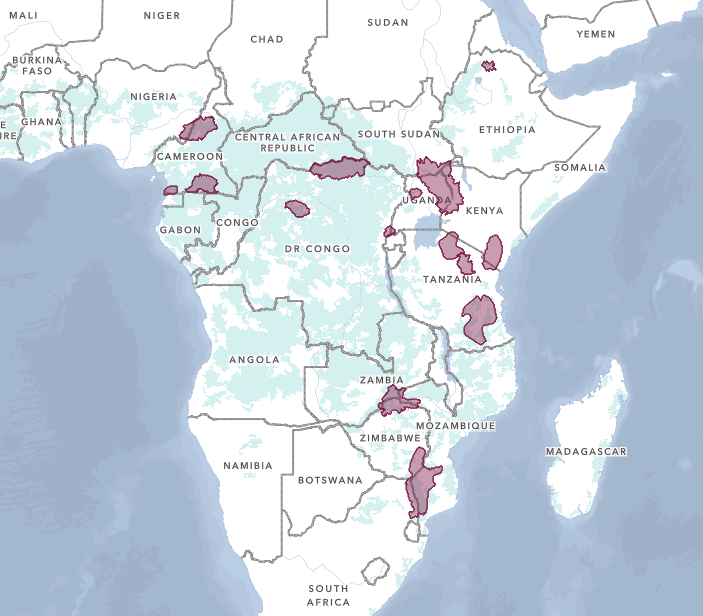
CURRENT AWF PRIORITY LANDSCAPES
Informing Priority Landscapes
AWF has applied spatial modeling to systematically consider a range of factors in order to identify 42 conservation landscapes across sub-Saharan Africa where conservation investment can have the most impact for people and wildlife. These landscapes are chosen based on the presence of AWF focal species, biodiversity richness, habitat integrity, ecosystem services (benefits like clean water that humans enjoy thanks to healthy, functioning natural systems), and more. See the landscapes where AWF currently has on-the-ground programs.
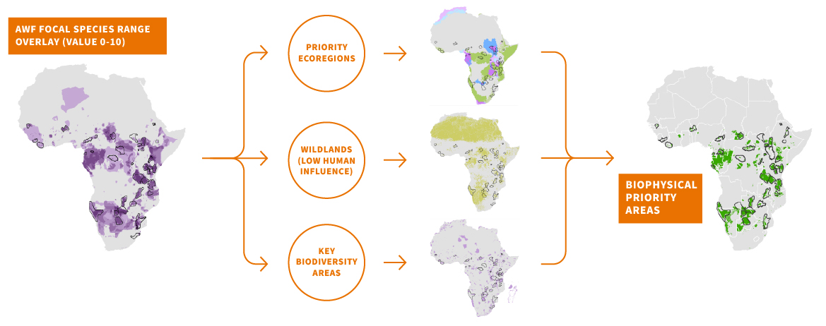
AWF uses key geospatial datasets on biodiversity, ecology, and development to identify focal landscapes.
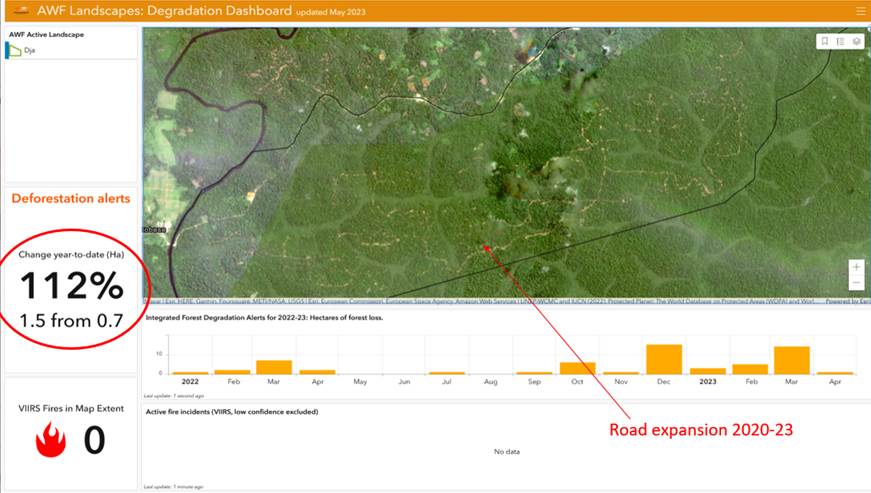
In 2023, the Degradation Dashboard flagged increased deforestation threats from a road expansion in Dja.
Degradation Dashboard: Mapping Habitat Degradation
Habitat loss and fragmentation make up the most significant long-term threat to Africa’s wildlife. AWF and Esri created a Degradation Dashboard that combines high-frequency predictions of potential illegal forest activity with high-resolution satellite imagery to provide early warning of forest degradation in the landscapes where we work. This helps wildlife managers to target appropriate responses to degradation and allows them to assess the impact of conservation actions over time.
In Dja Faunal Reserve, Cameroon, the dashboard flagged significant road expansion activity in a buffer zone that separates the park from other land uses. In March 2024, this led Cameroon’s wildlife authority and UNESCO to engage the community and prevent further expansion.
We created a version of the Degradation Dashboard to serve members of the Africa Civil Society Biodiversity Alliance (ACBA), where it has proved to be flexible for many uses, from assessing urbanization-driven forest degradation in Kenya to mapping the impact of oil infrastructure development in the Niger Delta.
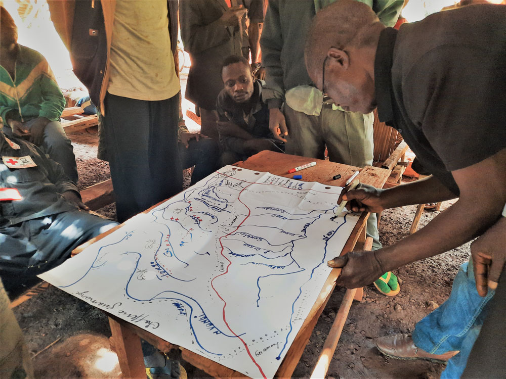
AWF engaged communities in the DRC's Bili-Uele landscape in a participatory land-use planning process.
Informing Decisions About Land Use
Where people place agriculture, towns, and roads impacts ecosystems and wildlife habitat. For example, development in an elephant movement corridor can result in human-elephant conflict, threatening the welfare of people and elephants alike. In landscapes like Bili-Uele in the DRC, we use participatory mapping and visualizations to support stakeholder understanding and better-informed discussions of issues involved with land use planning. These engagements incorporate analyses of the status, trends, and intersections of areas important to wildlife, ecosystem services, and livelihoods. AWF often uses scenarios to compare the status quo with sustainable, green growth alternative outcomes to help stakeholders plan conservation area expansions and infrastructure development. These green growth scenarios consider key areas for habitat and movement corridors for wildlife, ecosystem services like clean water, and local economies, livelihoods, and human well-being.

Developing Innovative Tools
Working closely with Esri, a global leader in spatial technology, we create new tools leveraging spatial data for conservation and sustainable development. The goal is to democratize access to data and data-informed insights so that Africans can make more effective, evidence-based decisions about natural resource management and land use.
We share these tools with African conservation partners, from local NGOs to government agencies, in such a way that they can adapt and scale the application of geospatial technology to fit their varied needs and agendas.
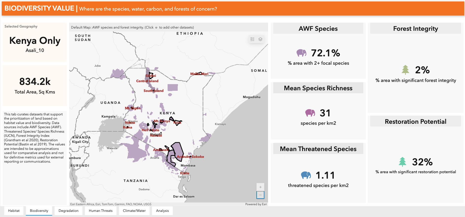
AWF uses TRACTS Scale in Kenya and other focal countries to assess map data. For example, this tab profiles areas with rich biodiversity.
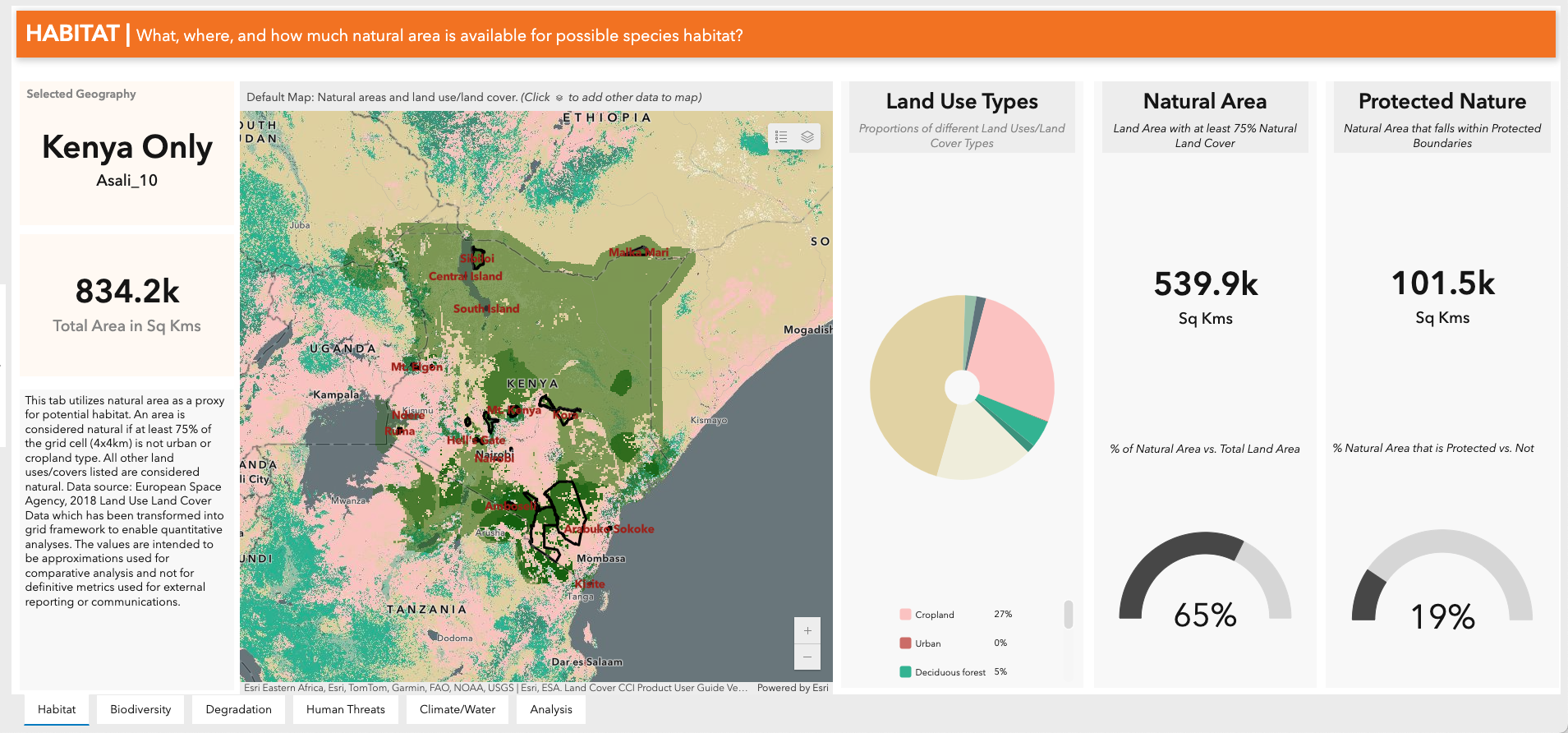
Other relevant frameworks that TRACTS Scale can assess include data on habitat (pictured here), climate change, and human-caused habitat degradation.
TRACTS Scale: Assessing Where to Invest for Sustainable Development
TRACTS Scale is an online tool that enables non-technical users to perform a data-rich assessment of a landscape or country for potential engagement or investment. With little training and no need for technical expertise, users can profile a range of spatial data, including potential habitat, species richness, land degradation, socio-economic context, climate change, and water resources. AWF uses this tool to inform our focal landscape strategy. The tool has the potential to inform decision-makers at multiple levels, from policymakers to conservation planners.
For example, with support from USAID, Okavango Capital Partners adapted TRACTS Scale to evaluate prospective companies for business models that can scale sustainably, investing in African-led engines of economic growth and sustainable use of nature.

TRACTS Sites: Turning Field Observations Into Conservation Action
Integrating data from camera traps, satellite imagery, and ranger patrol observations of wildlife (e.g. sightings, nests, and tracks) and threats (poaching indicators like snares, bullet cartridges, and camps), geospatial technology can inform wildlife managers to focus on wildlife-threat hotspots as they plan patrols and siting of outposts. This allows wildlife authorities and community wildlife scouts to prevent and react to poaching and human-wildlife conflict.
For years, we have supported rangers to collect data through the mobile CyberTracker application, for use in a ranger patrol data management software called SMART. Now, AWF and Esri have also developed TRACTS Sites, a situational awareness tool that informs protected-area managers to make faster, better-informed decisions with near real-time spatial information. The tool integrates a wide range of data from the field and remote sources, including SMART patrol observations of wildlife and illegal activity, satellite-captured habitat degradation, and environmental conditions such as fire incidents and vegetation conditions. Wildlife stewards can interpret and act on this rich conservation picture with minimal training.
This tool has been successfully deployed in Ethiopia’s Simien Mountains National Park, with a focus on monitoring fire risk and activity to plan fire management responses. The tool also monitors grazing trends inside the park, informing when the risk of illegal livestock grazing is likely to occur. AWF plans to scale use of the tool in Cameroon in 2024.
Risk Management Dashboard: Mapping Security Risks
Safety is a key factor that underpins thriving communities and wildlife populations. Decision-makers need data to gauge risks related to when and where violence and conflict could occur. AWF and Esri have developed a Risk Management Dashboard that identifies trends in insecurity stemming from conflicts and violence.
In the DRC’s Bili-Uele landscape, the Risk Management Dashboard provided independent verification of significantly decreased security risks owing to efforts by AWF and the DRC’s wildlife authority since 2020. The improved security picture is foundational for conservation and development efforts benefiting landscape inhabitants, who previously had limited access to markets and economic opportunities due to conflict. This work was funded by the European Union.
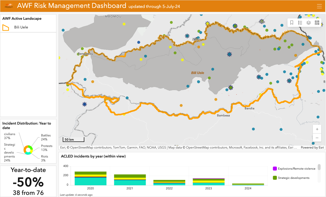
In the DRC’s Bili-Uele landscape, the Risk Management Dashboard indicates a decreasing trend of security incidents from 2020 to 2024.
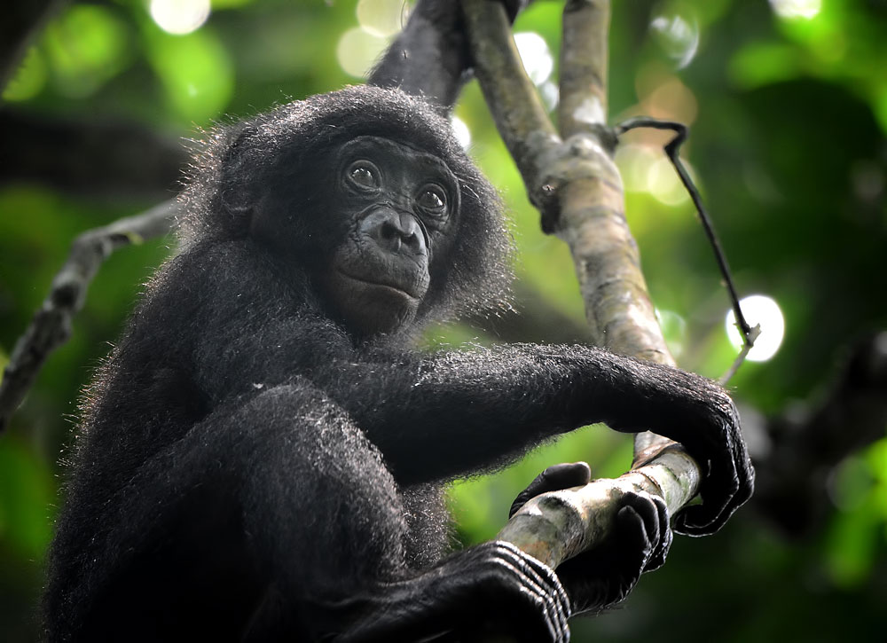
Predicting Future Habitat Suitability
We have also used this data to assess the suitability of restored range for at-risk species facing habitat loss, such as the bonobo. In the Maringa-Lopori-Wamba landscape, which spans 72,000 square kilometers (roughly the size of Panama) in the north-west of the Democratic Republic of the Congo, we used satellite-derived data and spatial modeling to identify areas throughout 60% of the landscape—inside and outside protected areas—that would be the most critical for bonobos.
See More of our Geospatial Work
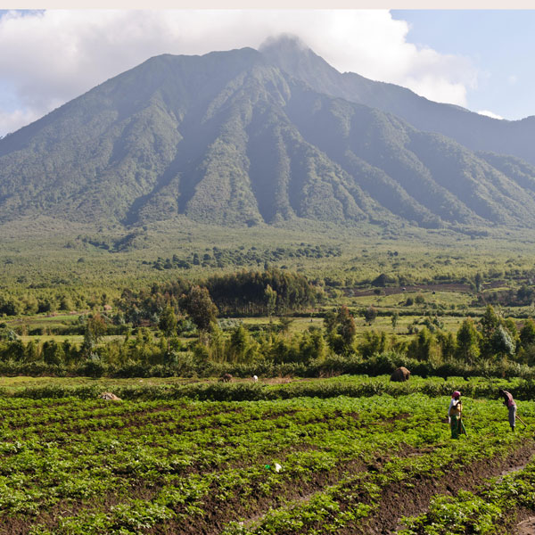
Story Map: Building Resilience for People and Mountain Gorillas in Rwanda
In Rwanda’s Volcanoes National Park, agriculture and human habitation had degraded mountain gorilla habitat, and around the park, limited land struggled to support the most densely populated area in Rwanda. Rwanda looked to restore lost areas of the park—as part of this vision, we used geospatial analysis to identify the restoration potential of degraded habitat. At the same time, Rwanda set aside space for greener, more efficient land use, providing new green infrastructure to support the well-being of people living around the park. Now, we’re supporting the government’s plan to restore 3,740 hectares of the park, starting with a pilot project to recover 732 hectares, build a green town, and create jobs and skills development opportunities, all with community input and free, prior, and informed consent.
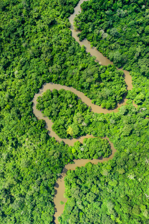
Story Map: Mapping Land Use in the Congo Basin
Mining, deforestation, and insecurity threaten critical habitat in the Bili-Uélé landscape, a remote area in northern DRC on the edge of the Congo Basin rainforest. To support this effort, we engaged local leaders in land-use planning workshops, partnering with them to designate 4,527 square kilometers for wildlife habitat. The community set aside other zones for regulated and sustainable use of the land, while the corridors allow wildlife to move between habitats uninterrupted, which is critical for ecosystem health. Explore an immersive story map for a detailed dive into how we’re enabling local communities to achieve security, rights, and ownership of conservation decision-making.
Using Data to Prevent Poaching in Zimbabwe and Zambia
Africa’s fourth largest river, the Zambezi, flows through the Mid-Zambezi Valley, a transboundary landscape shared by Zimbabwe and Zambia. In Mana Pools, the area of the landscape where AWF has worked with Tanzanian authorities, there has been a significant decline in elephant poaching, in part due to Cybertracker/SMART technology. The tools allow rangers to collect data on elephant mortality and patrol coverage, allowing for data-informed decision-making.